Fieldtrip
The organizers arranged 3 courses of field trips for registered participants.
The registration will be on a first-come, first-served basis.
The field trip sites are as follows:
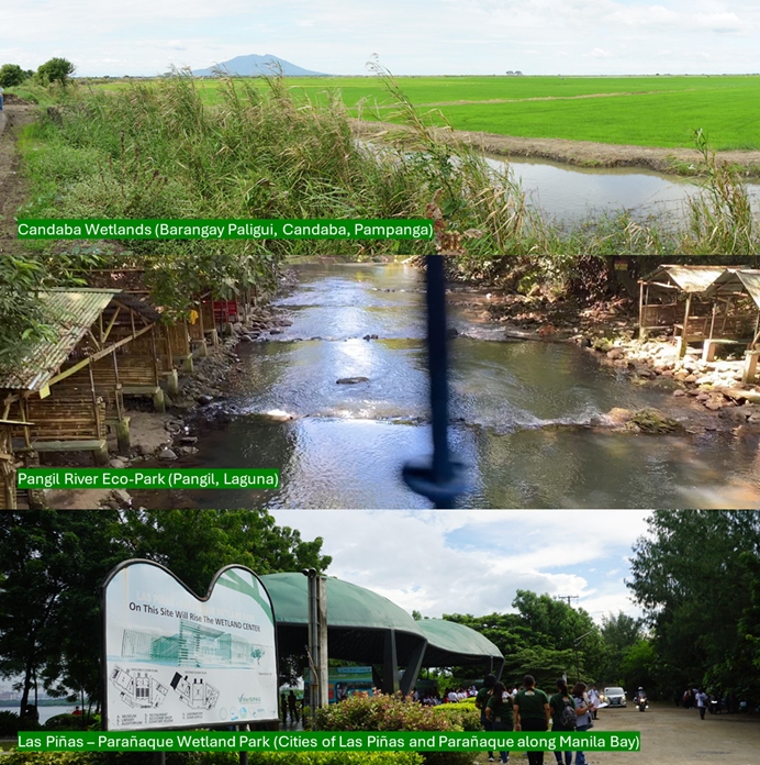
- Candaba Wetlands (Barangay Paligui, Candaba, Pampanga)
- Panguil River Eco-Park (Panguil, Laguna)
- Las Piñas – Parañaque Wetland Park (Cities of Las Piñas and Parañaque along Manila Bay)
Registration for the field trip will open as soon as details are finalized.

Candaba Wetlands (Barangay Paligui, Candaba, Pampanga)
The Society for the Conservation of Philippine Wetlands (SCPW) has been working with farmers in a 135-hectare rice farm in Candaba, Pampanga which is part of the approximately 32,000 hectares of wetlands straddling three provinces: Bulacan, Pampanga and Nueva Ecija. The Candaba Wetlands is an important area for agricultural and fisheries production, water irrigation, and natural flood retention. It is a Key Biodiversity Area (KBA #31) and an Important Bird Area (PH007) within the East Asian-Australasian Flyway (EAAF).
Candaba Swamp continues to be drained or converted into wet agriculture, severely limiting habitat for waterfowls. The change in land use has been observed in the towns comprising the Candaba Wetlands where large tracts of wetlands have been filled to give way to the housing subdivision and commercial establishments.
Panguil River Eco-Park (Panguil, Laguna)
Nestled at the heart of the fourth-class municipality of Panguil in Laguna is a 12-hectare ecological wonder – a clean and green, efficiently managed and lovingly maintained tourist resort owned, operated, and maintained by the local government. The Pangil River Eco Park is situated in alongside Panguil River.
The Pangil River (Tagalog: Ilog ng Pangil), also known as the Bambang Hari River, is a river system that runs through Pangil, Laguna, in the Philippines. It is one of 21 River tributaries of Laguna de Bay and is regularly monitored by the Laguna Lake Development Authority(LLDA) through one of its 15 river monitoring stations. The Pangil River sub-basin has a drainage area of 51.14 square kilometres (19.75 sq mi)
Las Piñas – Parañaque Wetland Park (Cities of Las Piñas and Parañaque along Manila Bay)
The Las Piñas – Parañaque Wetland Park (LPPWP) is a 181.63 hectare protected area located between the coordinates 14.481158, 120.971586 and 14.502763, 120.988237 or the southwest portion of Metro Manila and Manila Bay. The LPPWP divided into 2 main landmasses: Long Island is at the southwest portion of the LPPWP in Las Piñas City and Freedom Island is at the northeast part in Parañaque City. Predominantly covered by mudflats, LPPWP also has brush, grass, beach, dirt, and mangrove areas. Mangroves are the most prevalent plant species (8 species in total) in the area covering about 30 hectares.
Around 114 hectares of mudflats surrounding mangrove areas provide the opportunity for sources of food for about 5,000 birds per day. The count of different bird species range from 54 from the Department of Environment and Natural Resources – National Capital Region (DENR-NCR) to 80 bird species by the Wild Bird Club of he Philippines. Of these bird species, The Philippine Duck (Anas luzonica) and Chinese Egret (Egretta eulophotes) are vulnerable or is likely to become endangered unless the circumstances threatening its survival and reproduction improve. Also noteworthy are the Black-Winged Stilts (Himantopus himantopus) population in LPPWP which is estimated at about 1% of the total global population of Black-Winged Stilts. Twenty-nine migratory bird species were counted by DENR-NCR as migratory including the Siberian Rubythroat (Luscinia calliope). LPPWP lies within the migration path of migrant birds escaping the harsh Siberian Winter. Migratory birds feast on mudflat species from August to April. The LPPWP is a Ramsar Wetland of global importance.
